


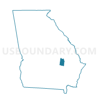
279514 - 514 S.T.I.A.L.C Voting District, Toombs County, Georgia
About
Outline

Summary
| Unique Area Identifier | 562963 |
| Name | 279514 - 514 S.T.I.A.L.C Voting District |
| County | Toombs County |
| State | Georgia |
| Area (square miles) | 4.86 |
| Land Area (square miles) | 4.75 |
| Water Area (square miles) | 0.11 |
| % of Land Area | 97.74 |
| % of Water Area | 2.26 |
| Latitude of the Internal Point | 32.22451970 |
| Longtitude of the Internal Point | -82.42774050 |
Maps


Graphs
Select a template below for downloading or customizing gragh for 279514 - 514 S.T.I.A.L.C Voting District, Toombs County, Georgia


Neighbors
Neighoring Voting District (by Name) Neighboring Voting District on the Map
- 20903 - HIGGSTON Voting District, Montgomery County, GA
- 2791823 - 1823 CENTER Voting District, Toombs County, GA
- 279511 - 511 OLD HEALTH Voting District, Toombs County, GA
- 279513 - 513 V.P.D. Voting District, Toombs County, GA
Top 10 Neighboring County Subdivision (by Population) Neighboring County Subdivision on the Map
- Vidalia-Lyons CCD, Toombs County, GA (23,867)
- Mount Vernon-Ailey CCD, Montgomery County, GA (4,861)
- Tarrytown CCD, Montgomery County, GA (1,978)
Top 10 Neighboring Place (by Population) Neighboring Place on the Map
Top 10 Neighboring Unified School District (by Population) Neighboring Unified School District on the Map
- Toombs County School District, GA (16,901)
- Vidalia City School District, GA (10,458)
- Montgomery County School District, GA (8,987)
Top 10 Neighboring State Legislative District Lower Chamber (by Population) Neighboring State Legislative District Lower Chamber on the Map
Top 10 Neighboring State Legislative District Upper Chamber (by Population) Neighboring State Legislative District Upper Chamber on the Map
Top 10 Neighboring 111th Congressional District (by Population) Neighboring 111th Congressional District on the Map
Top 10 Neighboring Census Tract (by Population) Neighboring Census Tract on the Map
- Census Tract 9703, Toombs County, GA (5,600)
- Census Tract 9702, Toombs County, GA (5,522)
- Census Tract 9502, Montgomery County, GA (4,861)
- Census Tract 9501, Montgomery County, GA (1,978)